Earlier this month, the Essex Rivers Hub Storymap officially went live and is now ready for viewing and using by both catchment partners and members of the public. This innovative resource acts as a significant tool in not only providing key data across the whole CaBA Catchment Partnership Area, but also transparency and clarity to the public.
The CaBA is a collaborative working approach, considering all aspects and individuals affected to deliver a range of environmental, social and economic benefits to protect our water environments by working at a river catchment scale in its entirety. Considering rivers from their sources to the sea, it allows us to contribute more efficiently towards creating a healthy water environment for the benefit of us all.
This new Storymap is an incredibly useful and dynamic tool that collates all aspects of relevant data into a single integrated resource. The different maps of data are easy to explore, providing geographic context to broaden the reader’s perspective and allowing all users, whether partner or public, to engage directly with the mapped data and the contextual information provided.
Some examples of the data able to be viewed using this resource includes floodplains, underlying geology, land use, habitat quality assessments, barriers to fish migration, storm overflows and more.
How to view the Storymap
For those interested in exploring this new live resource, click here to view the Essex Rivers Hub Storymap. This resource provides a wealth of data across the entire Essex Combined Management Catchment. It is easy to navigate from the first page detailing the Essex Rivers Hub Vision and Aims to the final page on Essex Rivers Hub Monitoring with all data and key information in contained within one accessible resource. Simply click through the five stories to explore everything this new resource has to offer.
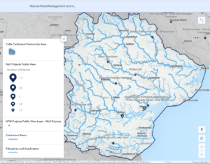
Natural Flood Management and Nature-based Solutions projects can be viewed under the Essex Rivers Hub Action page. Since future projects can be added and current projects continuously updated, the most up-to date information will always be available for partners and the public to interact with as it becomes further populated with projects in the region.
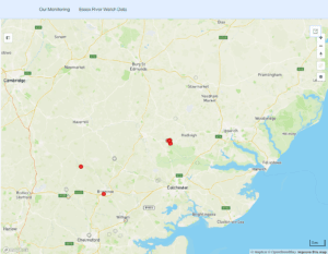
Insightful data is also available on the Essex Rivers Hub Monitoring page, highlighting all current water quality monitoring undertaken by Essex RiverWatch citizen scientists. It will also be exciting to watch as this map resource continues to fill up as we get closer to achieving our aim of engaging 100 citizen scientists by 2026 (Our Catchment Plan to 2030: Aim 2, objective c).
Being able to explore the character of the rivers and their tributaries within the catchment area delivers the holistic view of the Catchment Based Approach, embedding collaborative working at a river catchment scale that maintains a transparent communication between other partners and the public. By staying informed about the latest updates in ongoing projects, the public are able to play their role in advocating for future action and hold water companies and local politicians accountable for their environmental responsibilities.
Click here to view the Essex Rivers Hub Storymap